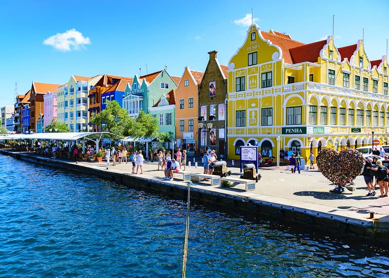
Curacao’s Colourful Waterfront Heritage and Dutch Caribbean Charm
The UNESCO World Heritage property “Historic Area of Willemstad, Inner City and Harbour” is a historic Caribbean port settlement located in Willemstad, the capital city of Curaçao, a constituent country within the Kingdom of the NETHERLANDS. Inscribed in 1997, the protected site encompasses over 190 hectares of urban land centered around Sint Anna Bay, a deep natural channel connecting the Caribbean Sea to the sheltered Schottegat lagoon. Established in 1634 following the Dutch conquest of the island, the city evolved into a major maritime trade hub.
The site consists of four historic districts showcasing three centuries of colonial town planning:
- Punda: The original walled settlement built on the eastern bank of the bay, anchored by Fort Amsterdam (1635).
- Otrobanda: Established in 1707 on the western side (“the other side”), featuring organic street patterns and residential courtyards.
- Pietermaai: Developed in the 18th century as a suburb east of Punda, known for grand townhouses.
- Scharloo: Expanded in the 19th century with opulent mansions built by wealthy merchants.
Willemstad is celebrated for its distinctive fusion of Dutch architecture and tropical Caribbean influences, dubbed “Curaçao Baroque.” Buildings feature steep gables, red clay roof tiles, open verandahs, and vivid pastel-painted facades—a tradition ordered in 1817 by Governor Albert Kikkert to reduce visual glare from white limestone walls.
Attraction
The historic area of Willemstad attracts global travelers with its vivid synthesis of European history, Caribbean color, and maritime energy. The iconic waterfront of Handelskade along Punda’s harbor edge presents one of the most photographed urban views in the Americas, with pastel-hued Dutch colonial buildings reflecting across Sint Anna Bay.
Visitors are drawn to the Queen Emma Bridge, a floating pontoon pedestrian bridge affectionately called the “Swinging Old Lady.” It swings open multiple times daily to allow ships into the harbor, offering a unique spectacle. The city’s walkable historic core features historic landmarks such as Fort Amsterdam, the Mikvé Israel-Emanuel Synagogue (the oldest continuously operating synagogue in the Americas, consecrated in 1732), and vibrant street art murals adorning Otrobanda’s alleyways. Beyond architecture, Willemstad offers boutique shopping, oceanfront dining, jazz bars, and seamless access to white-sand beaches and coral reefs.

World Heritage
Inscribed on the UNESCO World Heritage List in 1997, Willemstad was recognized as a Cultural World Heritage Site fulfilling criteria (ii), (iv), and (v):
- Criterion (ii) – Organic Multicultural Growth: The historic inner city illustrates the continuous organic development and integration of a multicultural colonial community over three centuries, reflecting European, African, Indigenous, Sephardic Jewish, and Latin American cultural strands.
- Criterion (iv) – Outstanding Colonial Port Ensemble: The site represents an exceptional, well-preserved example of a Dutch colonial trading settlement in the Caribbean. It retains its original 17th-century street layouts, defensible fortifications, and over 700 protected heritage buildings combining European architectural traditions with tropical climatic adaptations.
- Integrity and Authenticity: The urban spatial integrity remains intact, with the natural deep-water harbor continuing its historic function as a commercial port while maintaining strict preservation standards.
Gateway
The historic site is served directly by its host city as the primary entry point:
- Willemstad (Primary Gateway):
- Airport: Curaçao International Airport, also known as Hato International Airport (IATA Code: CUR; ICAO Code: TNCC).
- Infrastructure and Distance: Located on the southern coast of Curaçao, the airport sits approximately 12 kilometers north of Willemstad’s inner city. CUR handles daily international flights from North America, Europe (including direct flights from Amsterdam), Latin America, and neighboring Caribbean islands.
- Lodging and Transport: As Curaçao’s main city, Willemstad boasts extensive tourism infrastructure. Accommodations range from luxury beachfront resorts and restored historic boutique hotels in Pietermaai and Otrobanda to budget apartments. Transit options include taxis, airport shuttles, public buses (konvois), and rental cars. Licensed bilingual operators provide guided walking and harbor tours across all districts.
When
The ideal time to visit Willemstad is during the dry season from December to April.
- December to April (Peak Dry Season): Temperatures range between 26°C and 30°C (79°F to 86°F), accompanied by consistent tropical trade winds that keep humidity comfortable. Rainfall is minimal, providing optimal conditions for walking tours, outdoor dining, and coastal activities. Visitors during January or February can also experience the vibrant Curaçao Carnival celebrations.
- May to November (Shoulder & Off-Peak): Temperatures are slightly warmer (28°C to 33°C / 82°F to 91°F) with brief tropical showers in October and November. Sitting south of the main Caribbean hurricane belt, Curaçao remains a safe year-round destination.
Consideration
- Digital Immigration Card: All international travelers must complete the mandatory online Digital Immigration Card (DI Card) prior to arrival in Curaçao.
- Currency and Payments: The official currency is the Netherlands Antillean Guilder (ANG/Nafl), but US Dollars (USD) are universally accepted across the island. Major credit cards are widely used in hotels, restaurants, and shops.
- Language: Papiamentu and Dutch are official languages, but English and Spanish are widely spoken by service staff and residents.
- Pontoon Bridge Operations: When the Queen Emma Bridge opens for maritime traffic, free municipal ferries transport pedestrians across Sint Anna Bay.
- Sun Protection and Footwear: Tropical sun exposure is intense. High-SPF sunscreen, sunglasses, wide-brimmed hats, and comfortable walking shoes are necessary for exploring cobblestone streets and paved walkways.

Resources
- UNESCO World Heritage Centre: Official site listing providing detailed criteria, preservation updates, and boundary maps.
- Curaçao Tourist Board: Official tourism website offering travel guides, activity listings, accommodation links, and entry details.
- Curaçao Monuments Foundation: Portal detailing historic monuments, urban restoration projects, and architectural history.
- Organization of World Heritage Cities: Global network portal featuring Willemstad’s urban heritage profile and conservation news.
- GetYourGuide: Popular online travel booking engine providing tours, museum tickets, and harbor cruises in Willemstad.


Comments:
5 responses to “Historic Area of Willemstad, Inner City and Harbour, Curaçao”
-
Willemstad is delightfully walkable, with cobbled lanes, restaurants, shops and gabled houses that were painted white until 1817 when the Governor ordered them repainted in a palette of crayon colors to combat the glare from the sun. The oldest district, called Punda, is charming with a pastel-pretty waterfront and the big Curacao sign near the information booth where you can snag gratis maps of the city.
-
Visit the Kura Hulanda Museum where you can descend into the hold of a slave ship. The museum examines the transatlantic slave trade that once made Curacao a wealthy island.
-
Kura Hulanda is a truly first-class, if deeply disturbing, slavery museum. It was really worth seeing. And the Pontoon Bridge known as “the Swinging Old Lady” is a must-experience.
-
The charms of Willemstad, with its rainbow palette of gabled buildings accented with louvered shutters and white gingerbread trim, never lose their appeal. The winding cobblestone streets and alleyways of this 17th century city, located on Santa Anna Bay, are crowded with art galleries, restaurants, shops and little plazas shaded by acacia trees.
Enjoy a scoop of Lover’s, a super creamy island made ice cream or a slice of Dutch Apple Cake at the cafes while watching the Queen Emma Pontoon Bridge swing open and close letting walkers cross between Punda and Otrabanda districts of the city.
Stroll to the Floating Market, a Curacao tradition where boats from Venezuela, 38 miles away, tie up in early morning along the quay, displaying their wares of brilliantly colored fresh fruit, vegetables and flowers, mounds of glistening fish and such Caribbean specialties as tamarind candies and sugar cane. Take in the smells — and if you’re hungry, the tastes — of the foods cooked by vendors along the docks. Pause in Jo Jo Correa, a lovely plaza just across the street where artisans sell their wares.
-
The Queen Emma Bridge, called the “swinging old lady” by locals, is a pontoon bridge originally built in 1888 and restored in 2005/2006. I am told that it is free to cross NOW but originally there was a fee of 1/2 a cent to walk across the bridge if you were wearing shoes, but if you had no shoes on there was no fee (people caught on very quickly). As I was walking across the wooden bridge (with my shoes on) I could feel a slight bobbing motion and the slight sway of the bridge as it floats over the water. If you are crossing when it is windy, or the water is rough, it’s as if you are drunk, and I can well imagine this because even in calm waters I found it difficult to walk in a straight line.
The long bridge opens and moves to the side about 30 times per day to allow for ships to enter the harbour. When the bridge is open, free ferries called “ponchi” are in operation to accommodate people who wish to cross from side to side.
It is worth mentioning that even though St. Anna Bay looks narrow, it is very deep. It’s misleading when you are standing on the Queen Emma Bridge, and you look inland towards the 56 meters high Queen Juliana Bridge. But if you follow it further it opens up into a vast and deep shipping port area with container ships and dry docks.

Leave a Reply