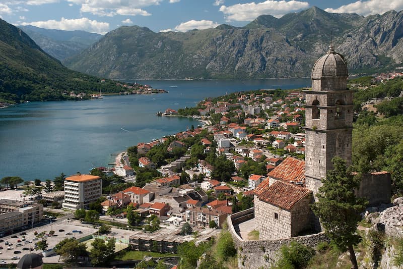
Kotor’s Breathtaking Coastline and Rich History
The UNESCO World Heritage property titled “Natural and Culturo-Historical Region of Kotor” is a coastal landscape in southwestern MONTENEGRO, situated along the inner inlets of the Bay of Kotor (Boka Kotorska) on the Adriatic Sea. Spanning 14,600 hectares of core land area and a 36,491-hectare buffer zone, this site encompasses a submerged river canyon—often dubbed southern Europe’s southernmost fjord—where towering limestone cliffs of the Dinaric Alps plunge directly into azure waters.
The protected region comprises several ancient coastal settlements, including the walled city of Kotor, the historic seafaring towns of Perast and Risan, and scenic islets such as Our Lady of the Rocks (Gospa od Škrpijela) and Saint George (Sveti Đorđe). The heart of the area is Kotor’s Old Town (Stari Grad), a labyrinth of narrow stone alleys, marble-paved plazas, Romanesque churches, and Venetian-era palaces. Enclosing the city is a 4.5-kilometer medieval fortification system featuring walls, gates, and bastions that scale up Mount Saint John to the Castle of Saint John (San Giovanni), perched 260 meters above sea level.
Attraction
The Kotor region captivates travelers through its dramatic alpine scenery, Mediterranean coastal views, and remarkably preserved medieval architecture. The main allure is the historic walled town of Kotor itself, where visitors wander past historic landmarks like the 12th-century Cathedral of Saint Tryphon, Saint Nicholas Church, the Maritime Museum, and charming plazas like the Square of the Arms. Hiking the 1,350 stone steps along the historic ramparts to Saint John’s Fortress rewards travelers with world-famous panoramas across the fjord-like bay.
Just a short drive or boat ride away, the picturesque village of Perast features baroque palaces and two iconic islet sanctuaries. Tourists take shuttle boats to visit Our Lady of the Rocks, an artificial island built by sailors over centuries, housing a historic church and museum. Outdoor enthusiasts enjoy sea kayaking, speedboat trips through the Blue Cave (Plava Špilja), stand-up paddleboarding, and scenic drives along the Serpentine Road ascending Mount Lovćen. The area’s maritime festivals, fresh seafood dining, and romantic coastal atmosphere continuously make it a prized Mediterranean destination.

World Heritage
Inscribed in 1979, the Natural and Culturo-Historical Region of Kotor was recognized as a Cultural World Heritage Site fulfilling criteria (i), (ii), (iii), and (iv):
- Criterion (i) – Harmonious Architectural Masterpiece: The property represents an extraordinary ensemble of historical monuments, churches, and urban settlements seamlessly integrated into the unique natural landscape of the Boka Bay gulf coast.
- Criterion (ii) – Influence on Adriatic Arts and Architecture: As Venice’s primary southern Adriatic stronghold, Kotor and its neighboring seafaring towns served as an influential creative hub. The region’s distinguished schools of stonemasonry, iconography, and goldsmithing exerted a lasting impact on coastal Mediterranean art.
- Criterion (iii) – Exceptional Cultural Authenticity: The region offers a unique, highly preserved testimony to centuries of continuous human settlement and maritime tradition in the Balkans, demonstrating exceptional structural authenticity despite surviving major seismic events, including the devastating 1979 earthquake.
- Criterion (iv) – Outstanding Urban Ensemble: The towns of Kotor and Perast stand as impeccably preserved small cities featuring high-quality Venetian, Romanesque, and Baroque architecture built in complete harmony with the dramatic coastal topography.
Additionally, Kotor’s defensive bastions were inscribed in 2017 under the transnational UNESCO listing “Venetian Works of Defence between the 16th and 17th Centuries.”
Gateway
Travelers visiting the Kotor region can utilize two practical gateways within Montenegro featuring active IATA-coded airports, lodging, transport links, and tour operators:
- Tivat (Immediate Coastal Gateway):
- Airport: Tivat Airport (IATA Code: TIV; ICAO Code: LYTV).
- Infrastructure: Situated on the Bay of Kotor 8 kilometers (5 miles) south of Kotor’s Old Town, Tivat Airport serves as the primary international gateway to Montenegro’s coast. Tivat and its luxury marina complex (Porto Montenegro) offer extensive lodging options ranging from boutique waterfront hotels to luxury rental apartments. Frequent public buses, private taxis, and car rentals connect Tivat to Kotor in 10 to 15 minutes. Local agencies provide licensed English-speaking guides and boat tours.
- Podgorica (National Capital Gateway):
- Airport: Podgorica Airport (IATA Code: TGD; ICAO Code: LYPG).
- Infrastructure: Located 85 kilometers (53 miles) east of Kotor, Montenegro’s capital city serves as the main year-round aviation hub. Podgorica offers abundant mid-range and luxury hotel accommodations. Excellent highway connections and direct intercity express buses run multiple times daily from Podgorica Central Bus Station to Kotor (taking roughly 1.5 to 2 hours), while travel desks organize full-day guided excursions to the coast.
When
The optimal period to visit the Natural and Culturo-Historical Region of Kotor is during Spring (May to June) and Early Autumn (September to October).
- Spring and Early Autumn: These shoulder seasons deliver pleasant weather with daily temperatures averaging 20°C to 26°C (68°F to 79°F), ideal for hiking ramparts and sightseeing without intense heat. Sea temperatures in May and September remain suitable for swimming, while tourist crowds and cruise ship traffic are significantly lower than in peak summer.
- Summer (July to August): Hot and sunny with temperatures exceeding 32°C (90°F). While popular for beach activities, Kotor’s narrow alleys become congested with cruise ship passengers, and road traffic around the bay becomes heavy.
- Winter (November to April): Mild but rainy (10°C to 15°C / 50°F to 59°F), with many boat tours operating on reduced schedules.
Consideration
- Cruise Ship Arrival Schedules: Large cruise ships dock daily at Kotor Port. Checking cruise port timetables allows visitors to schedule Old Town walks during quieter morning or evening hours when day-trippers depart.
- Challenging Rampart Hikes: Climbing to Saint John’s Fortress involves ascending 1,350 stone steps with minimal shade. Sturdy walking shoes, water, and sun protection are essential. Entrance fees apply during peak season.
- Narrow Coastal Roads and Traffic: The single-lane road encircling the Bay of Kotor experiences heavy traffic jams during summer. Utilizing water taxis or passenger ferries (such as the Kamenari-Lepetane ferry) is often faster than driving.
- Currency and Payment Methods: Montenegro uses the Euro (€) as its official currency despite not being an EU member state. Credit cards are accepted in major hotels and restaurants, but carrying cash is necessary for small market stalls and local boat drivers.
- Pedestrian Preservation Rules: Old Town Kotor is a pedestrian-only zone. Wheeled luggage must be carried over cobblestones, and strict noise ordinances protect the historic quarters.

Resources
- UNESCO World Heritage Centre: Official property listing detailing inscription values, boundary maps, and conservation reports.
- National Tourism Organisation of Montenegro: Official state portal providing regional travel guides, event updates, and transit links.
- Kotor Municipal Tourism Organisation: Local entity offering historic walking routes, city maps, and cultural calendars.
- Visit Montenegro: Comprehensive destination guide covering Bay of Kotor attractions, boat tours, and regional travel tips.
- GetYourGuide: Popular online travel booking marketplace offering guided walking tours, boat excursions, and day trips in Kotor.


Comments:
7 responses to “Natural and Culturo-Historical Region of Kotor”
-
The main entrance to the town was constructed in 1555 when the town was under Venetian rule (1420–1797). Visitors should look out for the winged lion of St Mark, Venice’s symbol, which is displayed prominently on the walls here and in several other spots around the town. Also worth taking is the steep path up to the Fortress of San Giovanni, which rewards with spectacular views of the UNESCO World Heritage Old Town below and Europe’s southernmost fjord.
-
Be warned, it’s easy to get lost wandering around this medieval city, purposefully built like a maze to bewilder invading forces and protect it from attack. Top tip: look out for the city’s main landmarks, like St. Tryphon’s Cathedral and St. Nicolas Church.
-
Kotor’s Stari Grad (Old Town) is nestled inside fortifications built during the Venetian period and features well preserved churches, charming squares, and informative museums that will take about two hours to explore on foot. The old town is so beautiful and surreal that you wouldn’t be the only one to think you had just stepped into a fairy tale, or on to the set of Game of Thrones.
The fortifications snake up the steep mountainside above the Old Town to the Castle of San Giovanni (Fortress of St John), also known to the locals as Tvrđave Kotora. Here, at 280 meters above sea level, is the most breathtaking panorama of the electrifying blue fjord and a spectacular bird’s-eye-view of the Old Town’s orange topped buildings below. A walk to the top of the fortress is certainly a must-do on any visit to Montenegro!
-
I love Kotor i stayed there summer last year for couple of days and i enjoyed wandering around the cobblestone alleyways and hiking up the fortress for the sunset view.
-
A labyrinth of rambling cobbled streets, hidden plazas and crumbling staircases that lead to nowhere, the old town of Kotor is the perfect place to spend an afternoon or three following your feet rather than a map and getting completely and delightfully lost. If you’re not a fan of hiking, then taking a leisurely stroll around town is probably one of the best things to do while you’re in Montenegro. Though some streets can seems a little dressed-up for tourists, take a few wrong turns and you’ll quickly find rows of pastel shutters listing in their frames, little old ladies hanging their washing overhead and the cute mewing cats for which this medieval town is famed.
-
Despite seeing many images of this place before my visit, nothing really prepared me for just how stunningly beautiful this bay is. The waterside setting (obviously) with its mountainous backdrop was for me a cross between the Norwegian fjords and those lovely Alpine lakes.
-
The symbol of strength of this town is, I would say, the Clock Tower, which lies in the middle of the town square. It is at an approximate 30-degree slant. Originally upright, a couple of massive earthquakes struck the region over the centuries and caused the structure to incline. Just a few hundred metres from the town square were the protective city walls. There were two routes to reach the top—the steep streets through the interior of the town, and the two-hundred-odd steps straight to the vantage point. I was quite lazy and didn’t want to walk, so I took the shortcut. When I reached up there, all I could see were dreamy blues, pantile roof houses and hundreds of yachts.


Leave a Reply