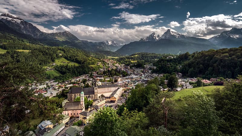
Berchtesgaden National Park anchors Bavaria’s sustainable mountain biosphere
“Berchtesgadener Land” (Biosphärenregion Berchtesgadener Land) is GERMANY’s only alpine biosphere reserve, spanning 83,984 hectares (roughly 840 square kilometers) in the southeastern corner of Bavaria along the Austrian border. Encompassing 15 municipalities across the Northern Limestone Alps and pre-alpine foothills, the reserve rises from 380 meters in the Salzach river floodplains to over 2,700 meters atop the Watzmann massif.
Its core and buffer zones align primarily with Berchtesgaden National Park and adjoining nature reserves, while its transition zone comprises young moraine hills, raised bogs, alpine pastures (Almen), and traditional small-scale farms. Supporting roughly 106,000 residents alongside rare alpine flora and wildlife—including golden eagles, Alpine ibex, chamois, and marmots—the region unites dramatic limestone peaks with living Bavarian alpine culture.
Attraction
Berchtesgadener Land attracts hikers, mountaineers, photographers, and cultural travelers globally who seek dramatic alpine lakes, steep limestone peaks, and historic Bavarian traditions.
Visitors glide by electric boat across emerald Lake Königssee to the onion-domed St. Bartholomä chapel and hike onward to Obersee, ride the Jennerbahn cable car for panoramic Watzmann views, and walk through the mossy boulders of the Zauberwald near Lake Hintersee. Travelers also tour the historic Berchtesgaden Salt Mine, relax in Bad Reichenhall’s brine thermal spas, explore moorland trails at Ainringer Moos, and experience seasonal Almabtrieb cattle drives and Advent markets.
Biosphere Reserve
Designated in 1990 under UNESCO’s Man and the Biosphere (MAB) Programme and expanded in 2010 to cover the entire Berchtesgadener Land district, the reserve is recognized for balancing strict alpine protection with sustainable regional livelihoods:
- Complete Alpine-to-Foothill Zonation: The reserve links undisturbed high-alpine ecosystems, glaciers, and mountain forests in Berchtesgaden National Park with species-rich cultural meadows, orchards, and moorlands in the pre-Alps.
- Regional Sustainability and Education: Through biosphere partner networks, local farm-to-table marketing, sustainable mobility initiatives, and environmental education, the region supports mountain farming, eco-conscious tourism, and climate adaptation.
Gateway
Because Salzburg Airport lies across the border in Austria, travelers entering within Germany use two proximate Bavarian aviation hubs—each verified in IATA’s official directory and offering overnight lodging, rail or highway links, and regional guides:
- Oberpfaffenhofen / Weßling (Nearest German IATA-Listed Airport Hub):
- Airport: Oberpfaffenhofen Airport (IATA Code: OBF; ICAO Code: EDMO).
- Infrastructure and Distance: Located southwest of Munich near Weßling, roughly 175 to 195 kilometers (about 2 to 2.5 hours by road via the A99 and A8 motorways) northwest of Berchtesgadener Land. OBF is an active general and business aviation airport indexed in IATA’s directory, supported by nearby lakeside and suburban hotels in the Starnberg–Weßling area, car rentals, and direct Autobahn access toward Bad Reichenhall and Berchtesgaden.
- Munich (Primary Bavarian International Gateway):
- Airport: Munich Airport (IATA Code: MUC; ICAO Code: EDDM).
- Infrastructure and Distance: Located roughly 180 to 205 kilometers (about 2 to 2.5 hours by road via the A8 motorway or roughly 2.5 to 3 hours by regional rail via Munich Ost and Freilassing to Bad Reichenhall and Berchtesgaden) northwest of the reserve. MUC is a major active public international airport indexed in IATA’s directory, backed by extensive city and airport hotels, car rentals, Deutsche Bahn rail links, and guided Bavarian Alps tour operators.
When
The ideal window to visit Berchtesgadener Land is from Late Spring to Early Autumn (May to October):
- Late Spring to Early Autumn (May to October): Recommended for high-alpine hiking, Königssee boat cruises, and pasture walks, offering snow-free mountain trails from June onward, mild valley temperatures of 14°C to 24°C (57°F to 75°F), and golden larch foliage with Almabtrieb festivals in September and October.
- Winter and November Shoulder (November to April): November is quiet with seasonal cable-car and hut closures, while December through March transforms the region into a snowy winter landscape suited to skiing, snowshoeing, thermal spas, and traditional Advent markets.
Consideration
- Use Your Overnight Guest Card for Free Regional Buses: Overnight visitors staying in Berchtesgadener Land receive a local Guest Card (Gästekarte) providing free travel on most regional buses and discounts on thermal baths, cable cars, and parking.
- Prepare for Alpine Microclimates and Afternoon Rain: Even in summer, high-altitude temperatures drop sharply and alpine thunderstorms or rain showers develop quickly; pack layered clothing, a waterproof shell, sun protection, and sturdy hiking boots.
- Book Peak Summer Boats and Cable Cars Early: Electric boats on Königssee, the Jennerbahn gondola, and salt mine tours see heavy demand between June and September; reserve timed tickets online and start early.
- Respect National Park and Moorland Rules: Stay on marked trails, avoid disturbing protected wildlife or fragile raised bogs, and follow seasonal trail closures.

Resources
- UNESCO Man and the Biosphere Programme (Berchtesgadener Land Profile): Official UNESCO portal detailing boundaries, elevation range, ecology, and socio-economic features.
- Biosphärenregion Berchtesgadener Land Official Portal: Dedicated Bavarian biosphere management portal covering partner businesses, sustainability projects, and regional trails.
- Berchtesgaden National Park Official Website: Official park authority portal providing trail regulations, conservation updates, and visitor center information.
- Berchtesgadener Land Tourism Official Portal: Regional destination website offering accommodation bookings, Guest Card mobility details, and excursion guides.
- GetYourGuide: Online travel booking marketplace offering affiliate-supported bookings for Berchtesgaden, Königssee, and Bavarian Alps day excursions from Munich.


Comments:
Leave a Reply