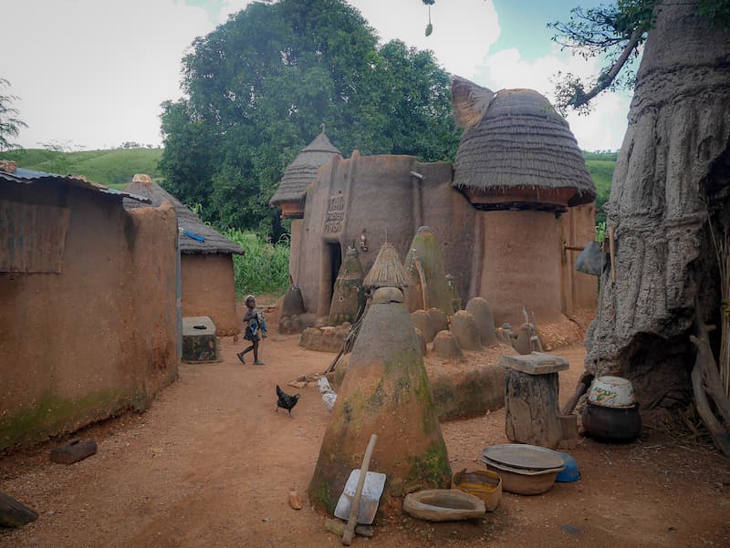
Koutammakou valleys unite sustainable agriculture with sacred architecture
The UNESCO World Heritage site titled “Koutammakou, the Land of the Batammariba” is a remarkable cultural landscape located in northwestern BENIN, extending across the border into neighboring Togo. Inhabited by the Batammariba people (also known as the Tammari or Somba), this rural landscape is famous for its unique traditional mud-tower houses, known locally as Takienta (or Tata Somba).
The Takienta are extraordinary multi-story fortress-like structures built entirely from clay, wood, and straw without modern industrial materials. These buildings are not merely residential homes; they represent a deep synthesis of family life, spiritual belief, defensive architecture, and agricultural practice. Each Takienta features round earth towers connected by thick mud walls, thatched or earthen roofs, elevated grain granaries, and built-in shrines dedicated to ancestors and nature spirits (voodoo/boitchi). Spanning hills, valleys, and agricultural fields, the landscape reflects a harmonious relationship between the Batammariba people, their spiritual customs, and the natural environment.
Attraction
Koutammakou draws cultural travelers, anthropologists, photographers, and architects seeking an authentic, living immersion into West African traditional heritage and vernacular architecture.
Visitors travel to marvel at the striking appearance of the Tata Somba fortresses, which resemble miniature castles scattered across the savanna. Tourists can take guided walking tours through traditional villages to explore the interior of these mud dwellings, observing how lower levels house livestock and kitchens while upper roofs serve as sleeping quarters and grain drying platforms. Beyond architecture, visitors experience living Batammariba traditions, including ritual scarification patterns, traditional hunting practices, animist shrine veneration, handcrafted pottery, and vibrant community dances. Exploring this untouched cultural landscape provides travelers with a rare, humbling glimpse into a society that has preserved its ancestral ways of life for centuries.

World Heritage
Inscribed initially in Togo in 2004 and expanded in 2023 to include the contiguous landscape in Benin, Koutammakou is recognized under Cultural Criteria (v) and (vi):
- Criterion (v) – Traditional Human Settlement and Land Use: The Takienta mud-tower houses and their surrounding agricultural land present an outstanding testimony to a traditional human settlement system. The landscape illustrates an enduring harmony between human building traditions, natural resource management, and social organization adapted to the physical environment.
- Criterion (vi) – Direct Association with Living Traditions and Beliefs: The landscape is directly associated with the living spiritual beliefs and cultural practices of the Batammariba people. The spatial layout of the Takienta, their internal structures, and surrounding sacred groves are intrinsically bound to ancestor worship, animist rituals, and traditional social customs.
Gateway
Travelers planning a visit to the Beninese section of Koutammakou can access the region via practical Beninese gateway locations featuring public IATA-listed airports searchable directly on IATA’s directory, complete lodging options, transit links, and tour operator services:
- Natitingou (Primary Local Gateway / Nearest Airport Hub):
- Airport: Natitingou Airport (IATA Code: NAE; ICAO Code: DBBN).
- Infrastructure and Distance: Located approximately 50 to 60 kilometers southeast of the Koutammakou region. NAE is a public airfield listed in IATA’s official directory. As the regional administrative capital of the Atakora Department, Natitingou provides extensive hotel lodging options, local guesthouses, car rentals, 4×4 transport services, and certified local tour guides running direct daily excursions into the Batammariba villages.
- Parakou (Primary Regional Transit Gateway):
- Airport: Parakou Airport (IATA Code: PKO; ICAO Code: DBBP).
- Infrastructure and Distance: Located roughly 200 to 220 kilometers southeast of Natitingou. PKO is an active public airfield indexed in IATA’s official directory. Parakou serves as the major commercial and transport hub of central-northern Benin, offering comfortable hotel infrastructure, rental vehicles, intercity bus terminals, and regional tour operators connecting travelers toward Natitingou and Koutammakou.
- Cotonou (Primary International Capital Gateway):
- Airport: Cotonou Cadjehoun Airport (IATA Code: COO; ICAO Code: DBBB).
- Infrastructure and Distance: Located approximately 550 to 600 kilometers south of Koutammakou. COO is the primary international aviation gateway of Benin listed in IATA’s directory. As the national economic center, Cotonou offers luxury hotels, international travel agencies, car rental companies, and long-distance transport routes heading north.
When
The ideal window to visit Koutammakou in northern Benin is during the Dry Season (November to March):
- Cool Dry Season (November to February): Highly recommended for comfortable travel. Daytime temperatures are warm, rainfall is minimal, and unpaved rural roads connecting villages are easily navigable. The dry weather makes outdoor walking tours through the Tata Somba villages pleasant.
- Late Dry Season (March to April): Hot and dry, with temperatures routinely rising above 35°C to 38°C (95°F to 100°F). Midday heat can be intense, requiring early morning or late afternoon village excursions.
- Wet Season (May to October): Heavy seasonal rains turn dirt roads and village tracks into deep mud, making travel to remote settlements challenging and occasionally inaccessible.
Consideration
- Respect for Cultural Etiquette: The Takienta are private ancestral homes and active sacred spaces. Always request permission from village elders or family heads before entering homes, taking photographs, or filming people.
- Local Guide Requirement: Hiring an official local Batammariba guide in Natitingou or Boukoumbé is highly recommended. Guides facilitate respectful entry into villages, translate local languages, and explain complex spiritual customs.
- Road Conditions and Transport: Accessing rural settlements requires driving on rough, unpaved dirt roads. Renting a sturdy 4×4 vehicle with an experienced driver is essential.
- Health and Medical Precautions: Malaria is endemic across the region. Taking prescribed malaria prophylaxis, using insect repellent, and sleeping under mosquito nets are crucial safety measures.
- Currency and Cash: The official currency is the West African CFA Franc (XOF). Credit card acceptance is non-existent in rural villages and limited in Natitingou. Carrying sufficient physical XOF cash for guide fees, entry donations, local crafts, and tips is mandatory.

Resources
- UNESCO World Heritage Centre: Official inscription portal detailing site boundaries, criteria evaluations, and state of conservation reports.
- Benin Tourism Official Portal: Official national tourism authority providing regional destination information, cultural itineraries, and transit logistics across northern Benin.
- Government of Benin Official Portal: Official state portal delivering national cultural preservation policies, Department of Atakora news, and administrative updates.
- Bradt Travel Guides (Benin Directory): Recognized travel destination publisher offering detailed logistical advice, background history, and village guidelines for visiting Natitingou and Koutammakou.
- Trip.com: Global online travel marketplace offering bookings for private guided tours, multi-day cultural circuits, and transport transfers from Cotonou or Natitingou to the Batammariba villages.


Comments:
Leave a Reply