 Germany
 United Kingdom of Great Britain and Northern Ireland
N54 59 33.4 W2 36 3.6
Date of Inscription: 1987
Extension: 2005,2008
Criteria: (ii)(iii)(iv)
Property : 526.9 ha
Buffer zone: 5,225.7 ha
Ref: 430ter
News Links/Travelogues:
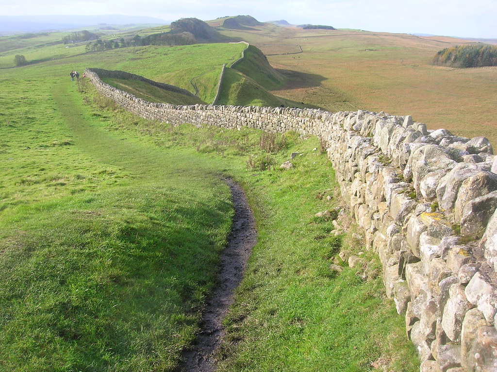
The ‘Roman Limes’ represents the border line of the Roman Empire at its greatest extent in the 2nd century AD. It stretched over 5,000 km from the Atlantic coast of northern Britain, through Europe to the Black Sea, and from there to the Red Sea and across North Africa to the Atlantic coast. The remains of the Limes today consist of vestiges of built walls, ditches, forts, fortresses, watchtowers and civilian settlements. Certain elements of the line have been excavated, some reconstructed and a few destroyed. The two sections of the Limes in Germany cover a length of 550 km from the north-west of the country to the Danube in the south-east. The 118-km-long Hadrian’s Wall (UK) was built on the orders of the Emperor Hadrian c. AD 122 at the northernmost limits of the Roman province of Britannia. It is a striking example of the organization of a military zone and illustrates the defensive techniques and geopolitical strategies of ancient Rome. The Antonine Wall, a 60-km long fortification in Scotland was started by Emperor Antonius Pius in 142 AD as a defense against the “barbarians” of the north. It constitutes the northwestern-most portion of the Roman Limes.
Brief Synthesis
The Roman Empire, in its territorial extent, was one of the greatest empires history has known. Enclosing the Mediterranean world and surrounding areas, it was protected by a network of frontiers stretching from the Atlantic Coast in the west to the Black Sea in the east, from central Scotland in the north to the northern fringes of the Sahara Desert in the south. It was largely constructed in the 2nd century AD when the Empire reached its greatest extent. This frontier could be an artificial or natural barrier, protecting spaces or a whole military zone. Its remains encompass both visible and buried archaeology on, behind and beyond the frontier.
The property consists of three sections of the frontier: Hadrian’s Wall, the Upper German- Raetian Limes and the Antonine Wall, located in the northwestern part of the Empire, constituting the artificial boundaries of the former Roman provinces Britannia, Germania Superior and Raetia: Running 130 km from the mouth of the River Tyne in the east to the Solway Firth, Hadrian’s Wall was built on the orders of the Emperor Hadrian in AD 122 as a continuous linear barrier at the then northernmost limits of the Roman province of Britannia. The frontier extended a further 36km down the Solway coast as a series of intervisible military installations. It constituted the main element in a controlled military zone across northern Britain. The Wall was supplemented by the ditch and banks of the vallum, supporting forts, marching camps and other features in a wide area to the north and south, linked by an extensive road network. It illustrates an ambitious and coherent system of defensive constructions perfected by engineers over the course of several generations and is outstanding for its construction in dressed stone and its excellent use of the spectacular upland terrain through which it passed.
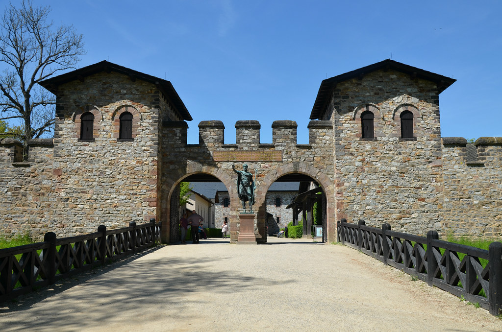
The Upper German-Raetian Limes covers a length of 550 km and runs between Rheinbrohl on the Rhine and Eining on the Danube, built in stages during the 2nd century. With its forts, fortlets, physical barriers, linked infrastructure and civilian architecture it exhibits an important interchange of human values through the development of Roman military architecture in previously largely undeveloped areas thereby giving an authentic insight into the world of antiquity of the late 1st to the mid-3rd century AD. It was not solely a military bulwark, but also defined economic and cultural limits. Although cultural influences extended across the frontier, it did represent a cultural divide between the Romanised world and the non-Romanised Germanic peoples. In large parts it was an arbitrary straight line, which did not take account of the topographical circumstances. Therefore, it is an excellent demonstration of the Roman precision in surveying.
The Antonine Wall was built under the Emperor Antoninus Pius in the 140’s AD as an attempt to conquer parts of northern Britain and extends for some 60 km across central Scotland from the River Forth to the River Clyde. Through its military and civil constructions, it demonstrates cultural interchange through the extension of Roman technical skills, organisation and knowledge to the furthest reaches of the Empire. It embodies a high degree of expertise in the technical mastery of stone and turf defensive constructions. As it was in use for only a single generation, it provides a snapshot of the frontier at a particular point in time and offers a specific insight into how the frontier was designed and built. Together, the remains of the frontiers, consisting of vestiges of walls, ditches, earthworks, fortlets, forts, fortresses, watchtowers, roads and civilian settlements, form a social and historical unit that illustrates an ambitious and coherent system of defensive constructions perfected by engineers over the course of several generations. Each section of the property constitutes an exceptional example of a linear frontier, encompassing an extensive relict landscape which reflects the way resources were deployed in the northwestern part of the Empire and which displays the unifying character of the Roman Empire, through its common culture, but also its distinctive responses to local geography and climate, as well as political, social and economic conditions.
Criterion (ii): The extant remains of the fortified German Limes, Hadrian’s Wall and Antonine Wall constitute significant elements of the Roman Frontiers present in Europe. With their forts, fortlets, walls, ditches, linked infrastructure and civilian architecture they exhibit an important interchange of human and cultural values at the apogee of the Roman Empire, through the development of Roman military architecture, extending the technical knowledge of construction and management to the very edges of the Empire. They reflect the imposition of a complex frontier system on the existing societies of the northwestern part of the Roman Empire, introducing for the first time military installations and related civilian settlements, linked through an extensive supporting network. The frontiers did not constitute an impregnable barrier, but controlled and allowed the movement of peoples: not only the military units, but also civilians and merchants. Hence, they triggered the exchange of cultural values through movement of soldiers and civilians from different nations. This entailed profound changes and developments in the respective regions in terms of settlement patterns, architecture and landscape design and spatial organization. The frontiers still today form a conspicuous part of the landscape.
Criterion (iii): As parts of the Roman Empire’s general system of defense the German Limes, Hadrian’s Wall and the Antonine Wall have an extraordinarily high cultural value. They bear an exceptional testimony to the maximum extension of the power of the Roman Empire through the consolidation of its northwestern frontiers and thus constitute a physical manifestation of Roman imperial policy. They illustrate the Roman Empire’s ambition to dominate the world in order to establish its law and way of life there in a long-term perspective. They witness Roman colonization in the respective territories, the spread of Roman culture and its different traditions – military, engineering, architecture, religion management and politics – and the large number of human settlements associated with the defenses which contribute to an understanding of how soldiers and their families lived in this part of the Roman Empire.
Criterion (iv): The fortified German Limes, Hadrian’s Wall and the Antonine Wall are outstanding examples of Roman military architecture and building techniques and of their technological development, perfected by engineers over the course of several generations. They demonstrate the variety and sophistication of the Romans’ responses to the specific topography and climate as well as to the political, military and social circumstances in the northwestern part of the Empire which spread all around Europe and thereby shaped much of the subsequent development in this part of the world.
Suggested bases:
Germany
Frankfurt is the largest city in the German state of Hesse, and is considered the business and financial centre of Germany. It is the fifth largest city in Germany after Berlin, Hamburg, Munich and Cologne. The city is known for its modern skyline, and for hosting the headquarters of the European Central Bank, the Deutsche Börse stock exchange and numerous German financial services companies. Furthermore, it hosts some of the world’s most important trade shows, such as the Frankfurt Auto Show and the Frankfurt Book Fair. Located on the river Main at a crossroad of the German Autobahn system and connected to several high-speed rail lines, with Germany’s busiest airport on its outskirts, Frankfurt is one of the most important transportation hubs of Europe. Frankfurt is a city of contrasts. Wealthy bankers, students and hippie drop-outs coexist in a city that has some of the highest, most avant-garde skyscrapers of Europe… [read more].
Munich is the capital city of the German federal state of Bavaria. Within the city limits, Munich has a population of more than 1.5 million, making it the third most populous city in Germany. Greater Munich including its suburbs has a population of 2.7 million. The Munich metropolitan region which extends to cities like Augsburg or Ingolstadt has a population of more than 5.6 million. Located at the river Isar in Southern Bavaria, it is famous for its beautiful architecture, fine culture, history and the annual Oktoberfest beer festival. Munich has a thriving cultural scene and many travellers are absolutely stunned by its architecture. Although it was heavily damaged by Allied bombing during World War II, many of its historic buildings have been rebuilt, including its largest church, the Frauenkirche cathedral, and the famous City Hall. Its numerous architectural attractions, sports events, zoo, exhibitions and the Oktoberfest attract considerable tourism. Munich… [read more].
Cologne is a city on the Rhine river in North Rhine-Westphalia. It is the fourth largest city in Germany with around one million residents. It is one of the nation’s media, tourism and business hotspots, and is considered one of the most liberal cities in Germany. Cologne has a rich history, reaching back to the time of the ancient Roman Empire, when it was founded. It has remained a constantly inhabited important regional centre since. Compared to other German and European cities, the ancient and medieval Cologne was relatively large, covering most of the modern-day city centre. A wealth of architectural heritage can therefore be found across the city ranging from pre-Christian times to strikingly modern buildings, with a high concentration of Romanesque and Gothic architecture, culminating in the magnificent cathedral (Dom). Cologne is, however, not only a tourist destination, but on an equal note a major economic centre, a globally important… [read more].
United Kingdom of Great Britain and Northern Ireland
Glasgow is the largest city in Scotland and the fourth-largest in the UK; with a population of about 625,000 (2018) in the city and 1,700,000 in the urban agglomeration (2018). Located at the west end of Scotland’s Central Belt on the banks of the River Clyde, Glasgow’s historical importance as Scotland’s main industrial centre has been challenged by decades of socio-economic and political change alongside various regeneration efforts. Despite this, Glasgow remains one of the nation’s key economic centres outside of London. Glasgow was awarded the European titles of City of Culture (1990), City of Architecture and Design (1999) and Capital of Sport (2003). In 2008, Glasgow became the second Scottish city to join the UNESCO Creative Cities initiative when it was named as a UNESCO City of Music. In preparing its bid, Glasgow counted an average of 130 music events a week; ranging from pop and rock to Celtic music… [read more].
Newcastle upon Tyne is a port city in the North East of England. It has a population of 250,000 but including the surrounding urban area its population is almost 1 million. It has among the best nightlife in all of Britain, and has a distinct Geordie vernacular. Newcastle is a lively and diverse city, known for its nightlife, art, music and sports. Compact, attractive and friendly, it is one of England’s core cities and is a centre of culture, architecture and business. Newcastle is a starting point for tours of the Northumberland coast and Hadrian’s Wall. The city is also home to the Geordie culture, with a rich heritage of folk music and dance and its own dialect. Newcastle was founded around 2,000 years ago as a Roman fort called Pons Aelius along Hadrian’s Wall, a ruin of which remains at Segedunum, a short walk from Wallsend Metro station. The city developed… [read more].
Manchester is a vibrant, post-industrial gem at the heart of North West England. The city that used to be nicknamed ‘Cottonopolis’ (a reference to its most famous export) has hung up its clogs and, thanks to successive regeneration projects, is now a major centre for culture and commerce; seen by many as the capital of the north of England, and sometime regarded as England’s second city. The site of the world’s oldest surviving passenger railway station and arguably the birthplace of socialism and the industrial revolution, Manchester remains at the vanguard of British culture and technology with a verve and vibe of its own. This vivacious spirit is augmented by the city’s two world-famous football clubs and large student population; whilst the mills have been swapped for Michelin stars and the warehouses for world-class shopping and museums, this is still a city that is very proud of its industrial past and… [read more].
