
 Andorra
Part of Communes of Encamp, Andorra la Vella, Saint Julia de Loria and Escaldes-Engordany
N42 29 41 E1 35 44
Date of Inscription: 2004
Minor boundary modification inscribed year: 2006
Criteria: (v)
Property : 4,247 ha
Ref: 1160bis
News Links/Travelogues:
The cultural landscape of Madriu-Perafita-Claror Valley offers a microcosmic perspective of the way people have harvested the resources of the high Pyrenees over millennia. Its dramatic glacial landscapes of craggy cliffs and glaciers, with high open pastures and steep wooded valleys, covers an area of 4,247 ha, 9% of the total area of the principality. It reflects past changes in climate, economic fortune and social systems, as well as the persistence of pastoralism and a strong mountain culture, notably the survival of a communal land-ownership system dating back to the 13th century. The site features houses, notably summer settlements, terraced fields, stone tracks and evidence of iron smelting.
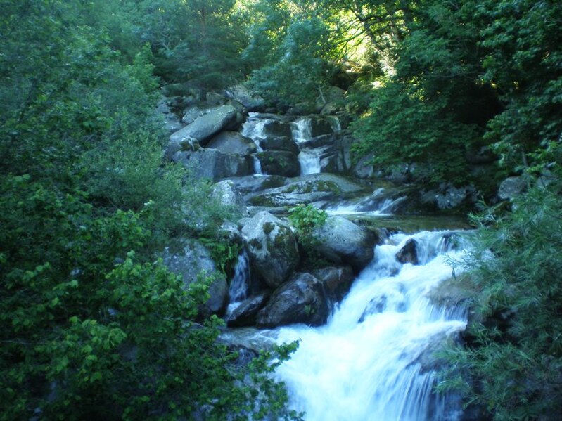
The Madriu-Perafita-Claror Valley is an exceptional geographical unit located in the south-eastern part of the Principality of Andorra, in the heart of the high Pyrenees. It covers an area of 4,247 ha or a little more than 9% of the national territory. A protective buffer zone of 4,092 ha surrounds this area.
The upper part of the valley is an exposed, dramatic glacial landscape, with spectacular craggy, steep cliffs, rock and lake glaciers. Lower down, the valley narrows and becomes more wooded, while in its lowest section the river flows into a short gorge. A secondary valley, the Perafita-Claror Valley, merges with the Madriu Valley from the South-West.
The extraordinarily well-preserved cultural landscape of Madriu-Perfita-Claror Valley offers a microcosmic perspective of the way in which inhabitants have harvested the scarce mountain resources of the high Pyrenees over the past millennia. It creates a sustainable living environment in harmony with the mountain landscape and bears complete testimony to a way of life and relationship between people and their land, between nature and culture. Its character is defined by the wise use of the resources offered by the mountain and by the deep respect for the associated values and qualities. It also reflects the survival and persistence of an ancient communal system of land ownership and management that has survived over 700 years, dating back to the 13th century – four communities own land within the property.
Its spectacular glacial landscapes with vast open pastures and steep wooded valleys reflect past climate change, the economic fortune and social systems, as well as the persistence of pastoralism and a strong mountain culture. The valley comprises amongst others diverse agro-pastoral complexes in the high mountain, agricultural centres in mid-mountain areas, a communication system based on a network of partially paved trails and the vestiges of a specific iron smelting and steelmaking activity: the Catalan Forge.
More precisely, the valley contains many traces of human occupation that express in a singular manner the perfect symbiosis and the precious balance between the land and humankind, between their resources and their needs; among these, bornes or small huts with vaulted stone roofs, some of which are still used by shepherds; orris in ruin, stables and cheese dairies, houses with side barns where grain and hay were stored; traces of terraced fields and foundries; low stone walls and paved tracks, etc. The valley also features houses, notably summer settlements.
Criterion (v) : The Madriu-Perafita-Claror Valley is a microcosm of the way the inhabitants have harvested the scarce resources of the high Pyrenees over the past millennia to create a sustainable living environment in harmony with the mountain landscape. The valley is a reflection of an ancient communal system of land management that has survived over 700 years.
Suggested Bases:
Andorra La Vella is the capital of Andorra. At an altitude of 1023 m it is Europe’s highest capital, and the only one located over 1 km above the sea level. You should be able to walk around most of Andorra la Vella. The town is really in two parts. There is the newer section at the north end of the town that is very commercial with lots of shops. The other half is the older half, down across the river and to the south and west. This also has shops, places to eat and the historic part. If you stay in either of these areas, you can easily cover on foot, but walking from the end of one half to the other will take a good half hour or more, so it may be worth taking the local bus which is cheap. Be sure to read the timetable and routes carefully on the bus stop [read more].
Escaldes-Engordany is a parish (administrative division) mainly to the east of Andorra La Vella but with main village of the same name 1.6 km N of the capital of Andorra on the road to La Massana and Ordino. The entire tourist area can be explored on foot. Av. Carlemany is pedestrian street and closed off to traffic from 12:00 to midnight daily. The greater part of Escaldes-Engordany stretches towards Spain and the east. Some wonderful walks are to be had up the Riu Madriu direction Pics del Pessons, the “lakes” and the Coll de Vall Civera. See Sant Miquel d’Engolasters. The rest of the year only at mass hours. Romanesque style, dated from 12th century and restored on 20th century. It is notable the disproportion between the nave and the 17-m bell tower. It is obligatory to reserve beforehand. Free-guided tours. Casa Creu, Modernist style, designed by the architect Josep Puig i Cadafalch [read more].
Encamp is a parish (administrative division) and town 4 km NE of the capital of Andorra between Andorra La Vella and the French border at Pas de la Casa (2085 m). Within the town of Encamp, you can get by with walking. There is also Funibus, which is a bus service run by the parish. Funibus takes passengers around Encamp and connect to the Funicamp gondola. The service is free and not restricted to skiers. See the historical Complex at les Bons: consisting of the 1 Sant Roma de les Bons Church, is a Romanesque building from the Lombard period dedicated to Sant Roma. It consisted of a defense tower, a water tank with an irrigation channel cut from the rock and a fortified house that correspond to the beginning of the Middle Ages. It is now a historical ruins. Free guided tours in July and August. Museu Nacional de l’Automobil (National Museum of Automobiles) [read more].
